
Contingency and the Cartographic Making of New England (Part 2)
In Part I, we explored how Southern New England’s borders emerged from surveying errors and charter conflicts. These disputes over the Southwick Jog, the Merrimack Bend, the Horse’s Neck, and the Pawcatuck Compromise were resolved through colonial negotiation, royal commissions, and local referendums. The stakes—which English colony controlled which strip of land—were relatively low.
But the northern borders of New England were settled under very different conditions. These were contests that were determined by wars and treaties that had little to do with either the natural landscape or the local population. The stakes at the northern borders were geopolitical—and therefore much higher.
Northern New England
The Sale of Maine
In the mid-1600s, Maine was a collection of struggling proprietary grants, most notably the Province of Maine owned by the Gorges family. Unlike the Puritans of Boston, the Gorges heirs were Royalists who struggled to manage their distant wilderness. In 1677, Massachusetts bought the rights to the Province of Maine for £1,250. Had the heirs sold to a French buyer or the British Crown, Maine would likely have developed as a separate Royal Province—one that, like Nova Scotia or Quebec, might have chosen not to join the American Revolution. Maine’s identity as the “North” of New England rather than the “South” of Canada was a matter of who had made the best offer.
The Haldimand Affair: Vermont’s British Flirtation
Before the Revolution, Vermont was disputed territory. Both New York and New Hampshire claimed it, and they fought hot wars over control. During the Revolution, the “Green Mountain Boys” of Vermont found themselves in an “unrecognized” status. Denied statehood by a Congress afraid of offending New York, the Allen brothers, who led the Green Mountain Boys, began the Haldimand Negotiations (1780–1784) with the British Governor of Quebec. The proposal was to make Vermont a British Province, complete with its own legislature. This would have driven a British wedge into the heart of new United States. The British defeat at Yorktown finally forced Vermont back into the American orbit. It was granted statehood in 1791.
The Province of New Ireland
During the War of 1812, the British occupied everything east of the Penobscot River and declared it the Province of New Ireland, with its capital at Castine. They intended it as a permanent buffer state. Many locals, feeling abandoned by Massachusetts, were content with British rule. If the Treaty of Ghent had not mandated a return to pre-war boundaries, the U.S.-Canada border would likely follow the Penobscot River today, and the “Down East” culture would be Canadian. In fact, Dalhousie University in Nova Scotia carries the legacy of New Ireland: its founding grant was provided by the tariff revenues British customs officers collected at Castine during the war years.
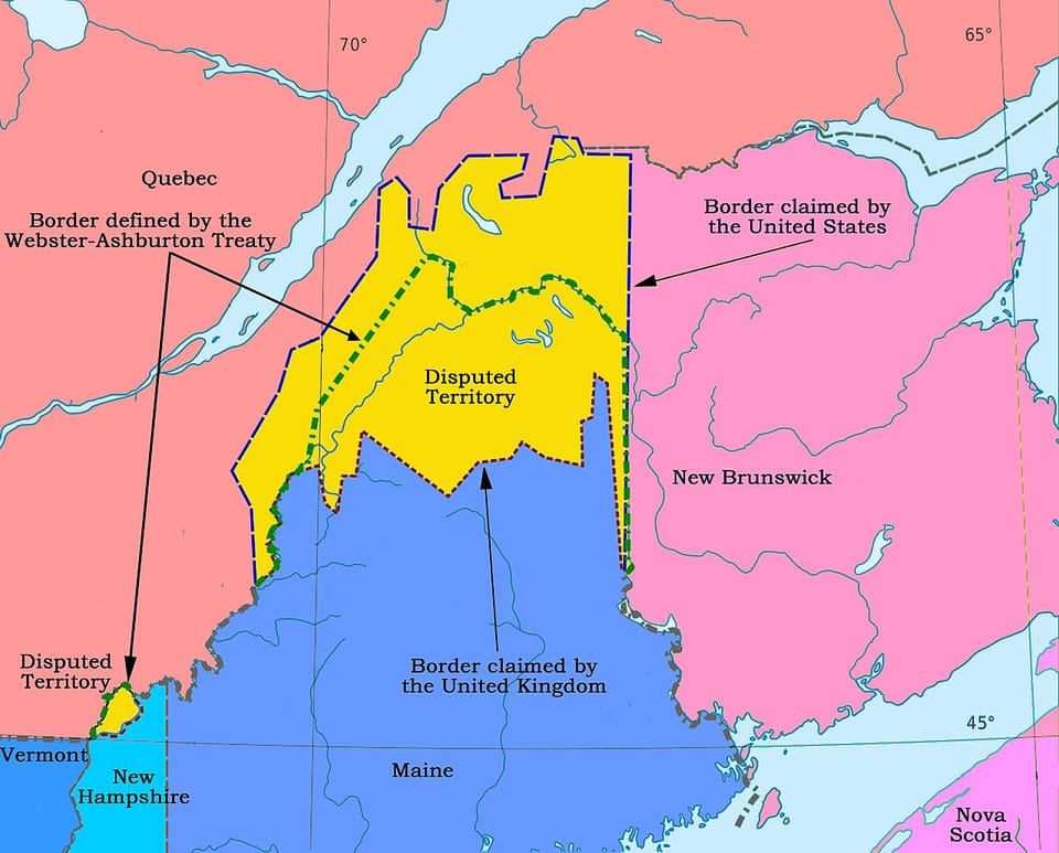
The Republic of Madawaska and the “Red Line” Map
The final resolution of the Maine-New Brunswick border is perhaps the greatest cartographic contingency of them all. For decades, the upper St. John Valley was home to the so-called Republic of Madawaska—a local Acadian population that flew its own flag—but was claimed by both Britain and the United States. The dispute was settled through cartographic bluffing. Secretary of State Daniel Webster discovered a map (the “Red Line Map”) that supported the British claim. He suppressed it in negotiations with the British, but used it to scare the Maine legislature into accepting a compromise line, lest they lose everything in a later arbitration. The 1842 Webster-Ashburton Treaty bisected the Acadian heartland, creating the split identity that remains today.
Two Alternative New Englands
If we synthesize these contingencies, these ones in the North and the ones in the South that we discussed in Part 1, we can imagine two radically different “Alternative New Englands.”
The Fragmented Fringe (Minimalist New England)
In this reality, every major data dispute and geopolitical negotiation goes against the Yankee center of Massachusetts and Connecticut.
The Map: New York successfully pushes its eastern boundary to the Connecticut River, absorbing all of Vermont and western Massachusetts and Connecticut. The Gorges heirs sell Maine to the Crown in the 1670s, and it develops as a separate Royal Province that remains loyal during the Revolution. The British “New Ireland” annexation of 1814 becomes permanent, with the Penobscot River as the international boundary.
The Geography: New England is reduced to a narrow, fragile coastal strip containing only Rhode Island, eastern Massachusetts (essentially Boston and Cape Cod), and the Connecticut shoreline from New Haven to Stonington. It’s a maritime region without a hinterland, boxed in by an even more powerful New York to the west and a dominant British North America to the north and east.
The Culture: This tiny New England has cultural force—the Puritan legacy, the maritime economy, the intellectual ferment of Boston—but almost no political weight. It’s perpetually overshadowed by the landed aristocracy of New York’s Hudson Valley and the Loyalist culture of British Maine and New Ireland. Vermont’s independent streak develops within British Canada rather than American federalism. The Yankee influence in American history is severely diminished. Without Vermont and New Hampshire, there’s no northern frontier. Without inland Massachusetts and Connecticut, there’s no industrial mill towns. The United States is a more southern, more agricultural, more slaveholding country.
The Atlantic Peninsula (Maximalist New England)
What if all the border disputes had gone the other way?
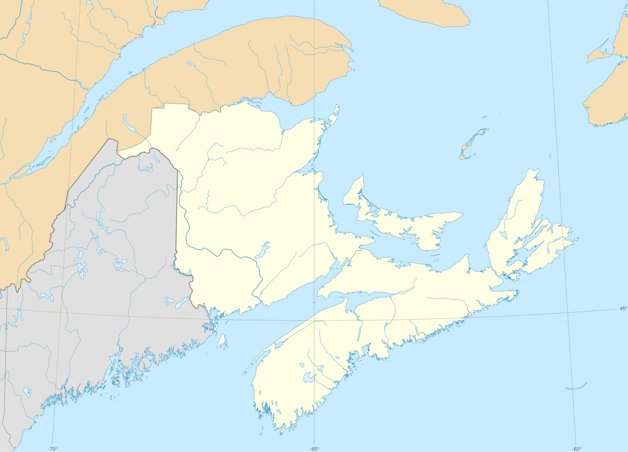
The Map: The western border follows the Hudson River/Lake Champlain corridor—a clear geological boundary that Massachusetts claimed in various 17th-century interpretations of its charter. The northern border follows the "St. Lawrence Highlands”—the true height of land that forms the St. Lawerence watershed. This interpretation, which Vermont and Maine advocated during various border disputes, would place New England's northern border along the Notre Dame Mountains north of the St. John River to Chaleur Bay (the current boundary between New Brunswick and Quebec).
The Geography: This New England is a topographically coherent Atlantic peninsula containing New Brunswick, Nova Scotia, Prince Edward Island, and all of present-day New England. To the south and west it includes Westchester, Putnam, Dutchess, and the other eastern counties of New York—and most likely Long Island as well. It’s defined by its relationship to the Atlantic fishing grounds and the Gulf of Maine ecosystem. The inland boundaries are physical: west of the Hudson-Champlain line, rivers flow to the Great Lakes and the Mississippi. North of the border, rivers flow to the St. Lawrence. South of border, rivers flow east and south into the Gulf of Maine and Atlantic Ocean.
The Culture: It is a region with natural cultural coherence. The Maritime Provinces come to share even more in common with Maine—the fishing economy, the Acadian heritage, the Protestant-Catholic mix, and the relationship to Boston as a cultural and economic center. The population is integrated into a broader Atlantic region rather than split from the rest of Anglophone Canada by Quebec. Vermont and New Hampshire are less anomalous—they’re the inland extension of a coastal culture rather than outliers. The entire peninsula speaks English, with French minorities in the north and pockets of Indigenous populations throughout.
This New England is more populous, more diverse, and more economically powerful than the New England we know. It controls the entire North Atlantic fishery. It has the industrial capacity of Massachusetts, the agricultural productivity of the Connecticut River Valley, the timber resources of Maine and New Brunswick, and the coal deposits of Nova Scotia. It’s the natural rival to New York and Pennsylvania, rather than their smaller neighbor.
But it’s also more vulnerable. A peninsula can be blockaded. During any war with Britain or France, the entire region is exposed to naval power in ways that the actual United States is not. This New England might develop differently. It might be more interested in naval power, more concerned with neutrality and free trade, and potentially more likely to pursue an independent foreign policy, alliances with British North America, or even separate nationhood.
What We Actually Got
Neither of these New Englands came to be. What we got instead is the product of accumulated accidents. The Southwick Jog remains because locals refused to change states. Vermont exists because the British lost at Yorktown and Congress eventually stood up to New York. Maine is American because Massachusetts made the best offer in 1677 and the British couldn’t hold it in 1815. The Maritimes are Canadian because the Continental Army failed to take Quebec in 1775–76 and because Webster suppressed a map in 1842.
The borders we see on today’s maps feel inevitable. But every notch and neck, every jog and compromise line, is an accident. Change any one of these contingencies and you get a different New England. The New England we know is just the one we got.
Member discussion